
2025 Project Monitoring Report
Salmon SuperHwy Success
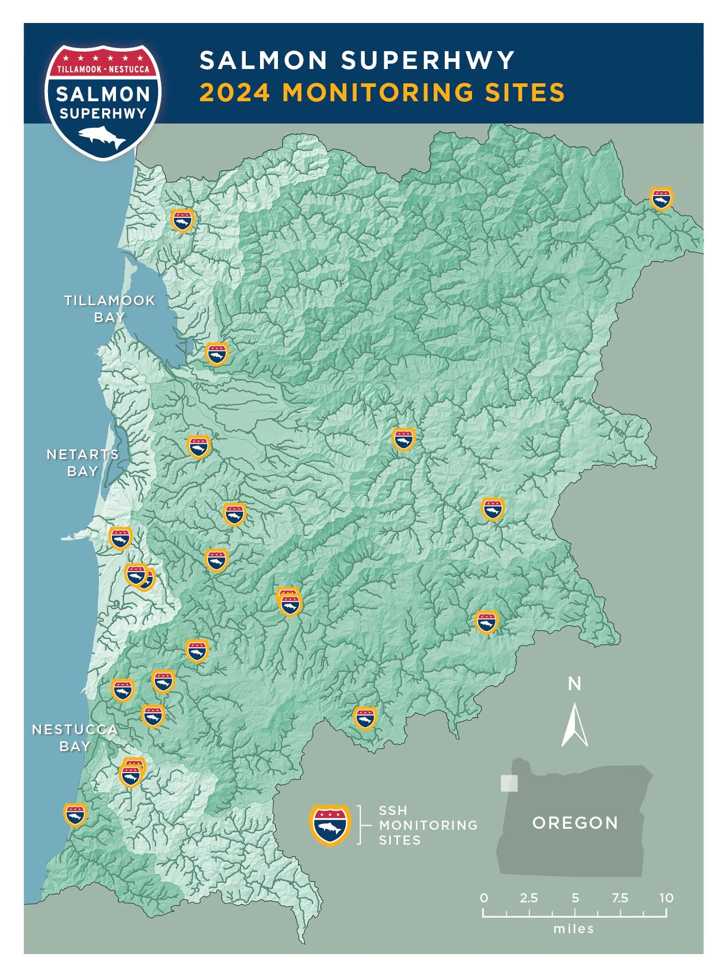
The unprecedented effort to restore access to almost 180 miles of blocked habitat throughout six major salmon and steelhead rivers of Oregon’s North Coast is proving successful. Monitoring of 24 sites thus far shows goals to reconnect historic habitat, restore fish passage, reduce chronic flooding and improve infrastructure have been met. Monitoring will continue into the future on a biannual schedule with the next report available in 2026. Congratulations to all the SSH partners on the success of this groundbreaking project.
Why Monitor?
The Salmon SuperHwy was formed with the intention of serving as a demonstration project, a model that could be applied to other drainages. Its application elsewhere cannot occur without monitoring. Monitoring is an important component of restoration projects. It helps us learn where we have been and when we have arrived; providing information and feedback on the design/planning process and improvements when needed. Monitoring tests assumptions and demonstrates the appropriate use of partner funds, helping to build trust and support.
Major Findings:
Out of the 24 sites monitored, all were found to be fish passable based on the parameters listed. During the time since implementation, these crossings have remained adequate for fish passage standards and maintained structural integrity. The determination of successful results at all monitored projects shows that efforts to restore fish passage in the Tillamook-Nestucca watershed have been effective in reconnecting blocked fish habitat in the project area. They also reflect major improvements to the safety and durability of the treated road-stream crossings. Enforcing this resilient infrastructure is a huge benefit to public safety and the local economy.
Lessons Learned:
Through conducting monitoring, it was observed that not all measurements would be accessible to take at some sites. Factors such as stream bed conditions sometimes mandated surveyors take measurements at a different time or supplement them with other parameters to prove passability. Changing site accessibility proved another factor since most projects are located on private property with unique landowner situations. As landowners change (or just change their minds) so does access permission making both monitoring and photo documentation more difficult. (Maintaining good relationships with landowners is a key motive of the Salmon SuperHwy partnership.) Some projects have poor pre/post project photo documentation due to these access issues. Staffing changes have also led to some pre/post project photos not being taken from the same perspective and not organized well for future use. Because of this, we have implemented an internal photo library which has solved these issues.
“Connecting communities, one fish at a time.”
Monitoring approach:
There are three types of monitoring: implementation, effectiveness, and validation monitoring.
Implementation monitoring determines whether planned activities have been implemented as designed.
Effectiveness monitoring determines if implementation has achieved desired goals and objectives.
Validation monitoring confirms the predicted results occurred and assumptions used to develop the action are correct.
The partnership’s monitoring approach includes both project implementation and effectiveness monitoring. Currently, implementation monitoring primarily assesses an individual road-stream crossing; it monitors whether the restoration project meets physical design criteria. The monitoring focuses on individual barriers because each site is unique and design approaches differ depending on the site conditions. Implementation monitoring focuses on documenting completed projects with before and after photos and noting any deviations from the project design and the reasons for any observed deviations. The SSH team documents and tracks all projects completed in a database containing information on project location, cost, timelines, partners, and miles of habitat reconnected. This team also produces project fact sheets for most completed projects, which are made available as appropriate on the partnership website.
Validation monitoring confirms that the predicted results occurred and that the assumptions used to develop the actions to address fish passage barriers, are correct. Validation monitoring is generally more labor-intensive and expensive than implementation and effectiveness monitoring because it requires evaluating fish and fish population response to the new structures. A broad-scale validation monitoring study that evaluated dozens of replaced fish passage barriers, including barriers within the Salmon SuperHwy’s geography, quantified the effectiveness of passage restoration on fish population abundance (Chelgren and Dunham 2015). The study results indicated that replacement of barriers with new crossings designed to allow for fish passage was associated with a dramatically higher probability of access for all fishes, including migratory Pacific salmon, trout, sculpin, and lamprey. Conversely, existing non-replaced crossings negatively impacted fish distributions (Chelgren and Dunham 2015).
passibility Criteria:
Through conducting monitoring, it was observed that not all measurements would be accessible to take at some sites. Factors such as stream bed conditions sometimes mandated surveyors take measurements at a different time or supplement them with other parameters to prove passability. Changing site accessibility proved another factor since most projects are located on private property with unique landowner situations. As landowners change (or just change their minds) so does access permission making both monitoring and photo documentation more difficult. (Maintaining good relationships with landowners is a key motive of the Salmon SuperHwy partnership.) Some projects have poor pre/post project photo documentation due to these access issues. Staffing changes have also led to some pre/post project photos not being taken from the same perspective and not organized well for future use. Because of this, we have implemented an internal photo library which has solved these issues.
Project Example:
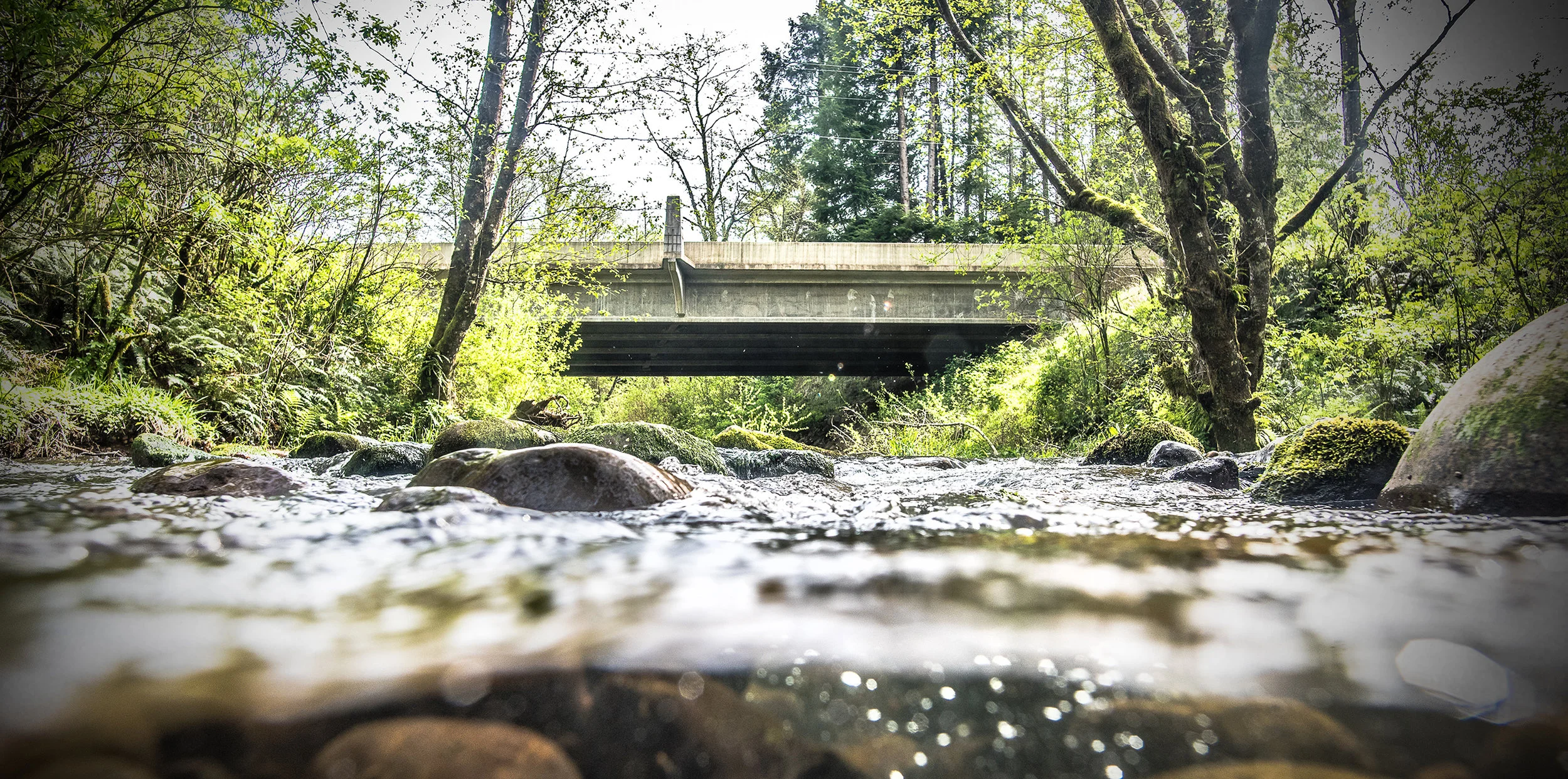
Partially funded by grants from the Infrastructure Investment and Jobs Act (BIL), a deteriorated culvert was replaced by a bridge on Samson Creek. 1.3 miles of blocked habitat were reconnected for five fish species while minimizing the possibility of road failure due to storms thereby reducing maintenance required by Tillamook County. Monitoring has confirmed that this project, along with all 24 others in the monitoring report, is deemed “PASSABLE” and has met all criteria. Success!
A deteriorated culvert was replaced by a bridge on Samson Creek
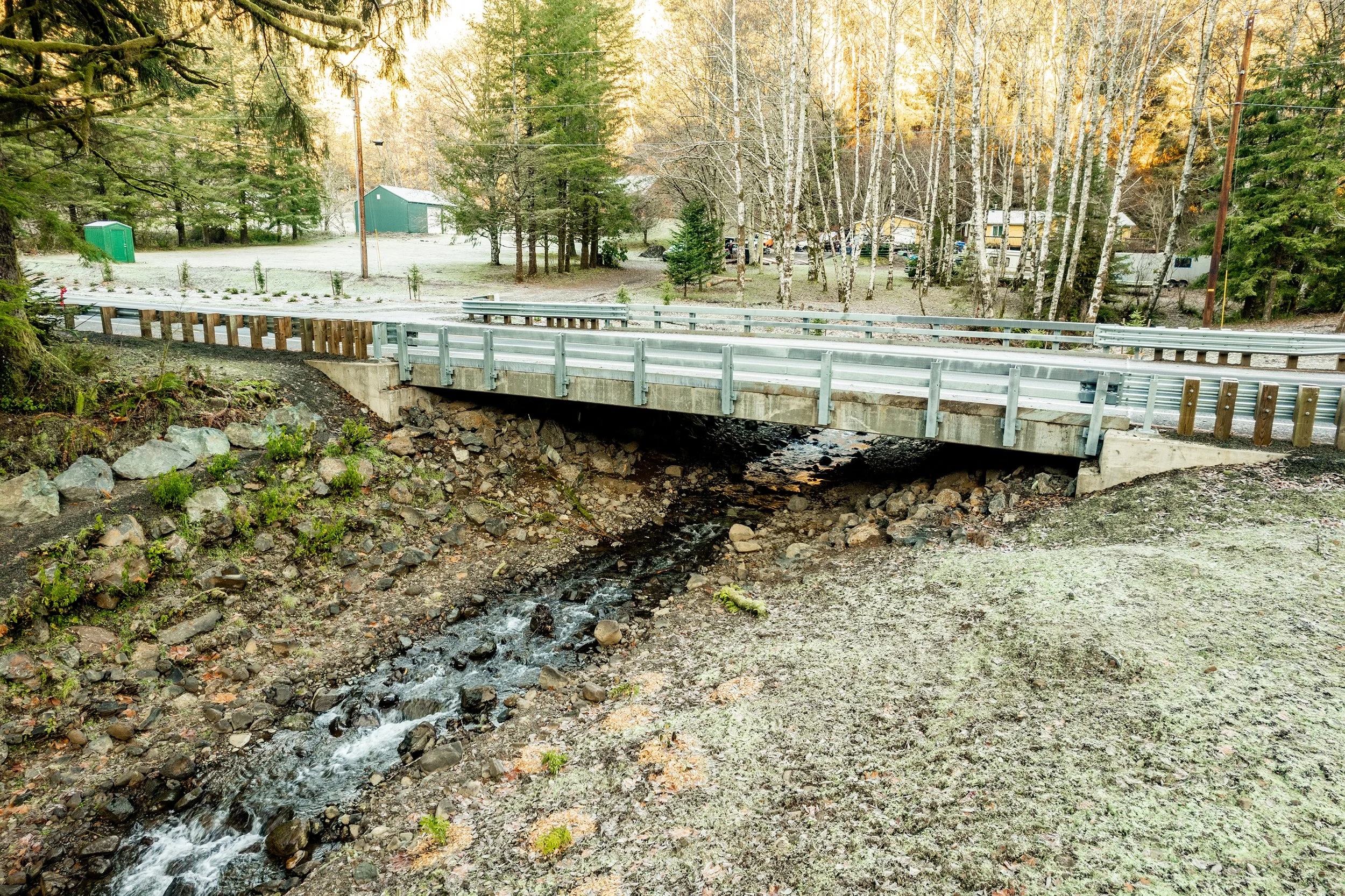
The undersized culvert was removed and replaced with a 46' clear span bridge, restoring 1.3 miles of upstream spawning and rearing habitat.